1. Grúz földrajz/Georgian geography (in English)
2. Kaukázusi etnolingvisztikai csoportok
3. Bevándorlási ügyek - a meghívólevél
4. Látnivalók/Worth to see (in English)
1. Georgian geography
OROGRAPHY AND HYDROGRAPHY
The highest mountain in Georgia is Mount Shkhara at 5,068 meters, and the second highest is Mount Janga (Jangi-Tau) at 5,059 m above sea level. Other prominent peaks include Kazbegi at 5,047 m, Shota Rustaveli 4,860 m, Tetnuldi 4,858 m, Mt. Ushba 4,700 m, and Ailama. Out of the abovementioned peaks, only Kazbegi is of volcanic origin. The region between Kazbegi and Shkhara (a distance of about 200 km along the Main Caucasus Range) is dominated by numerous glaciers. Out of the 2,100 glaciers that exist in the Caucasus today, approximately 30% are located within Georgia.
Georgia has about 25,000 rivers, many of which power small hydroelectric stations. Drainage is into the Black Sea to the west and through Azerbaijan to the Caspian Sea to the east. The largest river is the Mtkvari (known also by its other name, Kura which is still used in Azerbaijan), which flows 1,364 km from northeast Turkey across the plains of eastern Georgia, through the capital, Tbilisi, and into the Caspian Sea. The Rioni River, the largest river in western Georgia, rises in the Greater Caucasus and empties into the Black Sea at the port of Poti.
REGIONS
Georgia is naturally and historically divided into Western and Eastern Georgia. Currently country is divided into 9 regions, 1 city (Tbilisi), and 2 autonomous republics. These in turn are subdivided into 69 districts. The region boundaries almost correspond to that of the historical provinces: Guria, Imereti, Racha-Lechkhumi-Kvemo Svaneti, and Samegrelo-Zemo Svaneti are the western regions; Samtskhe-Javakheti, Shida Kartli, Kvemo Kartli, Mtskheta-Mtianeti and Kakheti are the eastern regions. The autonomous republics are Abkhazia in the North-Western Georgia and Adjara in the South-Western Georgia. Besides there number of small historical regions in the Eastern Georgia mountains: Tusheti, Pshavi, Khevsureti, Mtiuleti and Khevi.
Georgia is naturally and historically divided into Western and Eastern Georgia. Currently country is divided into 9 regions, 1 city (Tbilisi), and 2 autonomous republics. These in turn are subdivided into 69 districts. The region boundaries almost correspond to that of the historical provinces: Guria, Imereti, Racha-Lechkhumi-Kvemo Svaneti, and Samegrelo-Zemo Svaneti are the western regions; Samtskhe-Javakheti, Shida Kartli, Kvemo Kartli, Mtskheta-Mtianeti and Kakheti are the eastern regions. The autonomous republics are Abkhazia in the North-Western Georgia and Adjara in the South-Western Georgia. Besides there number of small historical regions in the Eastern Georgia mountains: Tusheti, Pshavi, Khevsureti, Mtiuleti and Khevi.
TOPOGRAPHY
The landscape within the country boundaries is quite varied. Western Georgia's landscape ranges from low-land marsh-forests, swamps, and temperate rain forests to eternal snows and glaciers, while the eastern part of the country even contains a small segment of semi-arid plains. Forests cover around 40% of Georgia's territory while the alpine/subalpine zone accounts for roughly around 10% of the land.
Much of the natural habitat in the low-lying areas of Western Georgia has disappeared over the last 100 years because of the agricultural development of the land and urbanization. The large majority of the forests that covered the Colchis plain are now virtually non-existent with the exception of the regions that are included in the national parks and reserves (e.g. Lake Paliastomi area). At present, the forest cover generally remains outside of the low-lying areas and is mainly located along the foothills and the mountains. Western Georgia's forests consist mainly of deciduous trees below 600 meters above sea level and comprise of species such as oak, hornbeam, beech, elm, ash, and chestnut. Evergreen species such as box may also be found in many areas. Ca. 1000 of all 4000 higher plants of Georgia are endemic in this country.
The west-central slopes of the Meskheti Range in Ajaria as well as several locations in Samegrelo and Abkhazia are covered by temperate rain forests. Between 600–1,000 metres above sea level, the deciduous forest becomes mixed with both broad-leaf and coniferous species making up the plant life. The zone is made up mainly of beech, spruce, and fir forests. From 1,500–1,800 meters, the forest becomes largely coniferous. The tree line generally ends at around 1,800 meters and the alpine zone takes over, which in most areas, extends up to an elevation of 3,000 meters above sea level. The eternal snow and glacier zone lies above the 3,000 meter line.
Eastern Georgia's landscape (referring to the territory east of the Likhi Range) is considerably different from that of the west, although, much like the Colchis plain in the west, nearly all of the low-lying areas of eastern Georgia including the Mtkvari and Alazani River plains have been deforested for agricultural purposes. In addition, because of the region's relatively drier climate, some of the low-lying plains (especially in Kartli and south-eastern Kakheti) were never covered by forests in the first place.
The general landscape of eastern Georgia comprises numerous valleys and gorges that are separated by mountains. In contrast with western Georgia, nearly 85% of the forests of the region are deciduous. Coniferous forests only dominate in the Borjomi Gorge and in the extreme western areas. Out of the deciduous species of trees, beech, oak, and hornbeam dominate. Other deciduous species include several varieties of maple, aspen, ash, and hazelnut. The Upper Alazani River Valley contains yew forests.
CLIMATE
Georgia's climate is affected by subtropical influences from the west and Mediterranean influences from the east. The Greater Caucasus range moderates local climate by serving as a barrier against cold air from the north. Warm, moist air from the Black Sea moves easily into the coastal lowlands from the west. Climatic zones are determined by distance from the Black Sea and by altitude. Along the Black Sea coast, from Abkhazia to the Turkish border, and in the region known as the Kolkhida Lowlands inland from the coast, the dominant subtropical climate features high humidity and heavy precipitation (1,000 to 2,000 mm per year; the Black Sea port of Batumi receives 2,500 mm per year). Several varieties of palm trees grow in these regions, where the midwinter average temperature is 5 °C and the midsummer average is 22 °C.
The plains of eastern Georgia are shielded from the influence of the Black Sea by mountains that provide a more continental climate. Summer temperatures average 20 °C to 24 °C, winter temperatures 2 °C to 4 °C. Humidity is lower, and rainfall averages 500 to 800 mm per year. Alpine and highland regions in the east and west, as well as a semi-arid region on the Iori Plateau to the southeast, have distinct microclimates.
At higher elevations, precipitation is sometimes twice as heavy as in the eastern plains. In the west, the climate is subtropical to about 650 m; above that altitude (and to the north and east) is a band of moist and moderately warm weather, then a band of cool and wet conditions. Alpine conditions begin at about 2,100 m, and above 3,600 m snow and ice are present year-round.
FAUNA
Because of its high landscape diversity and low latitude Georgia is home to about 1000 species of vertebrates (330 birds, 160 fish, 48 reptiles, and 11 amphibians). A number of large carnivores live in the forests, namely Brown bears, wolves, and lynxes. The species number of invertebrates is considered to be very high but data is distributed across a high number of publications. The spider checklist of Georgia, for example, includes 501 species.
Because of its high landscape diversity and low latitude Georgia is home to about 1000 species of vertebrates (330 birds, 160 fish, 48 reptiles, and 11 amphibians). A number of large carnivores live in the forests, namely Brown bears, wolves, and lynxes. The species number of invertebrates is considered to be very high but data is distributed across a high number of publications. The spider checklist of Georgia, for example, includes 501 species.

2. Etnográfia
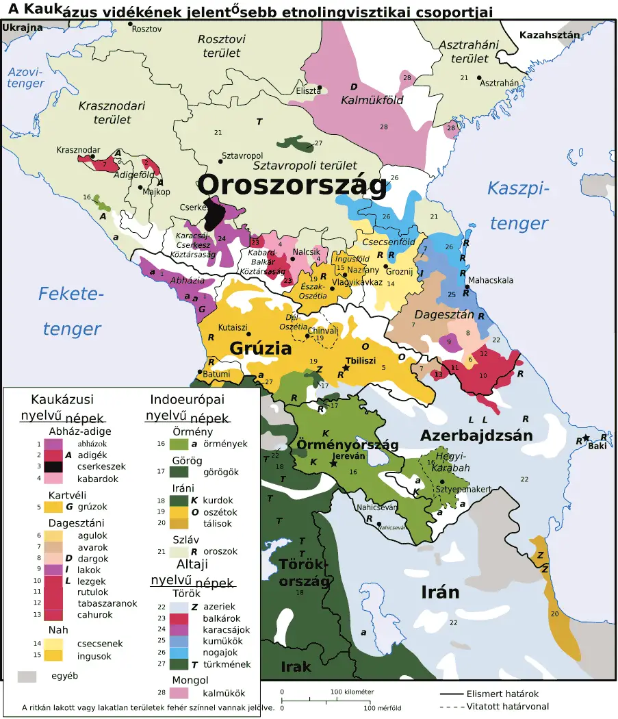 |
| http://mapsof.net/uploads/static-maps/caucasus_ethnic_hu.png |
3. Ha egy grúz Magyarországra szeretne látogatni...
Információk a meghívólevélről (a BÁV honlapjáról)
Látogatás céljából történő beutazás esetén az idegenrendészeti hatóság hozzájárulásával ellátott meghívólevél fogadható el. A meghívólevél iránti kérelmet erre rendszeresített formanyomtatványon, a kérelmező lakóhelye, tartózkodási helye vagy szálláshelye (jogi személy kérelmező esetén a székhelye) szerint illetékes regionális igazgatóságon lehet előterjeszteni. A meghívónak igazolnia kell, hogy a meghívott harmadik országbeli állampolgár részére – a Magyar Köztársaság területén történő tartózkodása időtartamára – szállást biztosít, ellátásáról gondoskodik, továbbá ha nemzetközi szerződés másként nem rendelkezik – egészségügyi ellátásának, valamint kiutazásának költségeit fedezi. A kötelezettségvállalás teljesítéséhez szükséges feltételek különösen az alábbi okiratokkal igazolhatók:
a) a lakhatás igazolására
– a kérelmező magyarországi lakásának tulajdonjogát igazoló, harminc napnál nem régebbi tulajdoni-lap másolattal;
– ha a lakásnak a meghívón kívül több tulajdonosa is van, csatolni kell továbbá a tulajdonosok két tanú aláírásával ellátott beleegyező nyilatkozatát;
– amennyiben a meghívónak nincs saját tulajdonú lakása, a lakásbérleti jogviszonyt igazoló lakásbérleti szerződéssel és az ingatlanra vonatkozó tulajdoni-lap másolattal;
b) a megélhetés, az egészségügyi ellátás és a kiutazás költségeinek fedezetére
- hat hónapra visszamenőleg kiállított munkáltatói kereset-igazolással;
- az előző évre vonatkozó APEH jövedelemigazolással;
- esetlegesen bankszámla-egyenleg csatolásával.
Az idegenrendészeti hatóság további iratok csatolását is kérheti.
A hatóság a meghívólevél érvényességét napokban, a meghívás céljára és a meghívás összes körülményére tekintettel állapítja meg. A meghívólevél legfeljebb 365 napig érvényes, ezért a meghívás, illetve a magyarországi tartózkodás időtartama is ehhez, illetve a hatóság által megállapított érvényességi időhöz igazodhat. A vízumkiadó hatóság által kiállított vízum érvényességi ideje eltérhet a meghívólevél érvényességi idejétől.
A meghívólevél önmagában nem jelent garanciát a vízum kiállítására, egyéb beutazási feltételek hiányában ugyanis a vízumkérelem elutasításra kerülhet.
4. Worth to see and know

1) Mestia - Historically and ethnographically, Mestia
has always been regarded a chief community of Zemo, or Upper Svaneti province.
Despite its small size, the townlet was an important centre of Georgian culture
for centuries and contains a number of medieval monuments - churches and forts
- included in a list of UNESCO World Heritage Sites. The townlet is dominated
by stone defensive towers of a type seen in Ushguli ("Svan towers").
A typical Svan fortified dwelling consisted of a tower, an adjacent house
(machub) and some other household structures encircled by a defensive wall. Mestia is also a center of mountaineer tourism and alpinism.
2) Jvari - is a small town at the northwestern edge of
Western Georgian province of Samegrelo-Zemo Svaneti. The town is situated on
the eastern bank of Enguri River and its name translates as "cross".
There is the Inguri Dam, a hydroelectric dam on the Inguri River located north
of the town Jvari. Currently it is the world's highest concrete arch dam with a
height of 272 meters. Jvari was the hometown of Meliton Kantaria, the sergeant
of the Soviet Army, who was photographed hoisting a Soviet flag Banner of
Victory over the Reichstag following the final defeat of Nazi Germany.
5) Poti - is a port city in Georgia, located on the
eastern Black Sea coast in the region of Samegrelo-Zemo Svaneti in the west of
the country. Built near the site of the ancient Greek colony of Phasis, the
city has become a major port city and industrial center since the early 20th
century. It is also home to a main naval base and the headquarters of the
Georgian navy. The Poti port area is planned to become a free economic zone
within the framework of a Georgian-United Arab Emirates project inaugurated in
April 2008.
6) Kutaisi - is Georgia's second largest city and the
capital of the western region of Imereti. Kutaisi was the capital of the
ancient Kingdom of Colchis. Archeological evidence indicates that the city
functioned as the capital of the kingdom of Colchis as early as the second
millennium BC. It is widely believed by historians that when Apollonius Rhodius
was writing about Jason and the Argonauts and their legendary journey to
Colchis, Kutaisi/Aia was the final destination of the Argonauts and the
residence of King Aeëtes. Kutaisi is one of the most important educational and
scientific centers in Georgia, hosting the Gelati Academy of Sciences,
established in the 12th century by King David IV. There is also one of the most
important educational centers in modern Georgia, Ak'ak'i Ts'ereteli State
University, established in 1930. The landmark of the city is the ruined Bagrati
Cathedral, built by Bagrat III, king of Georgia, in the early 11th century. The
Bagrati Cathedral and the Gelati Monastery a few km east of the city, are
UNESCO World Heritage Sites. One of the famous churches in Georgia is Motsameta
Church. It is named after two saints, brothers David and Constantine. They were
the Dukes of Margveti, and were martyred by Arab invaders in the 8th century.
Besides the churches, there are many interesting places in Kutaisi, such as:
Sataplia Cave, where one can observe footprints of Dinosaurs; Geguti Palace,
which was one of the residences of Georgian monarchs; "Okros
Chardakhi" – Georgian Kings’ Palace; and the Pantheon, where many notable
citizens are buried.
* the
Adjara State Museum
* Batumi
Botanical Garden, started (like the previous) by professor Krasnov (brother of
the general Pyotr Krasnov)
*
aquarium
*
circus
*
Medea statue
*
former resort area along the Black Sea coast.
10) The Baku–Tbilisi–Ceyhan pipeline is a 1,768
kilometres long crude oil pipeline from the Azeri-Chirag-Guneshli oil field in
the Caspian Sea to the Mediterranean Sea. It connects Baku, the capital of
Azerbaijan; Tbilisi, the capital of Georgia; and Ceyhan, a port on the
south-eastern Mediterranean coast of Turkey, hence its name. It is the second
longest oil pipeline in the former Soviet Union after the Druzhba pipeline. The
first oil that was pumped from the Baku end of the pipeline on 10 May 2005
reached Ceyhan on 28 May 2006.
11) The cave city of Vardzia - is a cave monastery dug into the
side of the Erusheli Mountain in southern Georgia near Aspindza on the left
bank of the Mtkvari River. It was founded by Queen Tamar in 1185. The monastery
was constructed as protection from the Mongols and consisted of over six
thousand apartments in a thirteen storey complex. The city included a church, a
throne room, and a complex irrigation system watering terraced farmlands. The
only access to the complex was through some well hidden tunnels near the Mtkvari
river. In the modern days Vardzia is a major tourist attraction in the
Samtskhe-Javakheti region of Georgia. The place is maintained by a small group
of monks and can be visited for a small fee. About three hundred apartments and
halls remain visitable and in some tunnels the old irrigation pipes still bring
drinkable water.
12) The Kars–Gyumri–Tbilisi railway line - is a railway line that runs from
the city of Kars in Turkey to the Armenian city of Gyumri, then from there on
to Tbilisi, Georgia. Originally completed in 1899, the railway has been highly
important during the Soviet era, both as the only rail link between Turkey and
the USSR (Kars-Gyumri), and one of the two main railway connections between
Armenia and other Soviet Republics (Gyumri-Tbilisi). While the Gyumri-Tbilisi
section remains Armenia's lifeline to the outside world, the Kars-Gyumri
section has not been operational since 1993, when Turkey following the
Nagorno-Karabakh War between Armenia and Turkic-speaking Azerbaijan closed the
border with Armenia in support for the Azeris in the war with Armenia. Since
the Kars–Gymri section has not been in operation due to the closed
Turkish-Armenian border, in April 2005, an agreement was signed to build a
direct connection across the Turkish-Georgian border from Kars to Georgia's
Akhalkalaki, and to rehabilitate the existing railways from Akhalkalaki via
Tbilisi to Baku, this creating the Kars–Tbilisi–Baku mainline. Most of the
countries including European Union and United States have said they will not
assist in promoting or developing the proposed Kars–Tbilisi–Baku railway line.
13) Homo Georgicus - is a species of Homo that was suggested in
2002 to describe fossil skulls and jaws found in Dmanisi, Georgia in 1999 and
2001, which seem intermediate between Homo Habilis and Homo Erectus. The
fossils are about 1.8 million years old. The remains were first discovered in
1991 by Georgian scientist, David Lordkipanidze, accompanied by an
international team which unearthed the remains. Implements and animal bones
were found alongside the ancient human remains.
At first, scientists thought they had found
mandibles and skulls belonging to Homo Ergaster, but size differences led them
to name a new species, Homo Georgicus, which would be the descendant of Homo
habilis and ancestor of Asian Homo Erectus.
14) Tbilisi - is the capital and the largest city of
Georgia, lying on the banks of the Mt'k'vari (Kura) River. The name is derived
from an early Georgian form T'pilisi and it was officially known as Tiflis
until 1936. The city covers an area of 726 km² and has 1,480,000 inhabitants.
Founded in the 5th century by Vakhtang
Gorgasali, the Georgian King of Iberia, and made into a capital in the 6th
century, Tbilisi is a significant industrial, social, and cultural centre. The
city is also emerging as an important transit route for global energy and trade
projects. Located strategically at the crossroads between Europe and Asia and
lying along the historic Silk Road routes, Tbilisi has often been a point of
contention between various rival powers and empires. The history of the city
can be seen by its architecture, where the 19th century Rustaveli
Avenue and downtown are blended with the narrower streets of the medieval
Narikala district.
The demographics of the city are diverse and
historically it has been home to peoples from diverse cultures, religions and
ethnicities. Despite being overwhelmingly Orthodox Christian, Tbilisi is one of
the few places in the world (Sarajevo and Paramaribo being others) where a
synagogue and a mosque are located next to each other, in the ancient Bath
district several hundred meters from the Metekhi Church. Notable tourist
destinations include the Holy Trinity Cathedral of Tbilisi, Freedom Square,
Sioni Cathedral, Metekhi, Narikala, Rustaveli Avenue, Tbilisi Opera and Ballet
Theatre, Anchiskhati Basilica, Mtatsminda Pantheon (Holy Mountain), Kashveti
Church along with the National and Historic Museums of Georgia and a number of
art galleries. Tbilisi is the home of famous artists. The city life was
immortalized in their art by Niko Pirosmani and Lado Gudiashvili.
15) Mtskheta - one of the oldest cities of the country of
Georgia (in Kartli province of Eastern Georgia), is located approximately 15
kilometers north of Tbilisi at the confluence of the Aragvi and Kura rivers.
The city (population 19,423 as of January 1, 2008) is now the administrative
centre of the Mtskheta-Mtianeti region. Due to its historical significance and
numerous ancient monuments, the "Historical Monuments of Mtskheta"
became a UNESCO World Heritage Site in 1994. The old city lies at the
confluence of the rivers Mtkvari and Aragvi. The rare blend of cultural values
had ruled in this part of the world since the Bronze Age until prosperous
Christian era over the unique eclectic lifestyle creating the mood of the town
which is as old as the history of Georgia. Mtskheta is the most religious city
of Georgia as it has been the shrine of pagan idols since times immemorial and
it is where Christianity in Georgia takes its origin. The sightseeing includes
Svetitskhoveli Cathedral (11th century) and Jvari Monastery (6th century) in Mtskheta
are amongst the most significant monuments of Georgian Christian architecture,
and are historically significant in the development of medieval architecture
throughout the Caucasus. Of special significance are early inscriptions, which
form a valuable reference in the study of the origins of the early Georgian
alphabet.
In the outskirts of Mtskheta are the ruins of
Armaztsikhe fortress (3rd century BC), the Armaztsikhe acropolis (dating to the
late 1st millennium BC), remains of a "Pompey's bridge" (according to
legends built by Roman legionnaires of Pompey the Great in 1st century BC), the
fragmentary remains of a royal palace (1st–3rd century AD), a nearby tomb of
the 1st century AD, a small church of the 4th century, the Samtavro Monastery
(11th century), and the fortress of Bebris Tsikhe (14th century). The Institute
of Archaeology, and the garden of Mikheil Mamulashvili are also worthy of note.
16) Sighnaghi - is a town in Georgia's easternmost region of
Kakheti and the administrative center of the Sighnaghi District. It is one of
the country's smallest towns with a population of 2,146 as of the 2002 census.
Sighnaghi's economy is dominated by production of wine, traditional carpets and
Georgian traditional food Mcvadi. The town and its environs are also known for
their landscapes and historical monuments. Sighnaghi has recently undergone a
fundamental reconstruction program and has become an important center of
Georgia's tourist industry. The town is walled with the remnants of
18th-century fortifications. There are two Georgian Orthodox churches in the
town itself - one dedicated to St. George and the other to St. Stephen. The
venerated Bodbe Monastery is located 2 kilometers from Sighnaghi and is a place
of pilgrimage due to its association with St. Nino, the 4th-century apostle of
Georgia. The local Ethnographic and Archaeological Museum dating from the 1950s
was upgraded and developed into a modern-standard exhibition the – Sighnaghi
Museum – in 2007. Sighnaghi is known as a "Love City" in Georgia.
17) Telavi - is
the main city and administrative center of Georgia's eastern province of
Kakheti. Telavi and its surroundings are rich by historical, architectural and
natural monuments. The most important heritage monuments preserved within the
city limits include:
*
"Dzveli Galavani" (old walls) - fortress of the first Kakhetian kings
(9-10th centuries, AD);
*
Church of the St. Mary (16th century, AD);
*
Church of the Holy Trinity (6th century, AD);
*
Fortress "Batonis Tsikhe" (fortress of master) built in 17th century,
AD - this is the only well-preserved medieval royal palaces in Georgia;
*
"Korchibashishvilebis Tsikhe" - castle of local noblemen
Korchibashishvilis (16-18th centurty, AD);
*
"Vakhvakhishvilebis Tsikhe" - castle of local noblemen
Vakhvakhishvilis (18th centurty, AD).
Telavi is the only city in Georgia, where four
fortification monuments from different historical periods remain relatively
intact. Due to this reason, architects, scholars and art historians consider
Telavi as the most "medieval" cities in the country. Another curious
sight in Telavi is a 900-year-old sycamore (45 meters high, 12.4 meters around
the trunk). Other notable landmarks around Telavi include the Alaverdi
Cathedral (11th century AD) - the second highest cathedral in Georgia after the
newly built Tbilisi Sameba Cathedral, the Ikalto Academy (8-12th centuries AD)
- where the famous Georgian writer Shota Rustaveli studied, the Church of St.
George (dedicated to the patron saint of Georgia; it is said that in Georgia
there are 365 churches in the name of St. George), ruins of the city and castle
of Gremi (the former capital of Kakheti from the 15-17th centuries AD), Shuamta
- a complex made up of three churches of different periods - 6th, 7th and 8th
centuries in a highland forest, Akhali Shuamta ("New Shuamta" in
English) - the monastery close to Dzveli Shuamta ("Old Shuamta" in
English), built in the 16th century, the stunning Tsinandali Gardens (the
residential Palace of Noblemen Chavchavadzes family) and many others. Telavi
district is known for its excellent vineyards.
18) Shatili - is a historic highland village in Georgia,
near the border with Chechnya. It is located on the northern slope of the
Greater Caucasus mountains, in the historical Georgian province of Upper
Khevsureti, which is now part of the modern-day region (mkhare) of
Mtskheta-Mtianeti. Located in the deep Arghuni gorge at approximate 1,400
meters, the village is actually a unique complex of medieval-to-early modern
fortresses and fortified dwellings of stone and mortar which functioned both as
a residential area and a fortress guarding the northeastern outskirts of the
country. The fortress consists of the terraced structures dominated by
flat-roofed dwellings and some 60 towers which cluster together to create a
single chain of fortifications. The population of Shatili, along with that of
most of the Khevsureti, was resettled under the pressure from the Soviet
authorities to the plains in the early 1950s. In the 1960s, the exotic
landscape of the empty village was used as a setting for a series of Georgian
films about the past life of the highlanders. Shatili is still inhabited by a
dozen or so families, but is inaccessible by road during wintertime. The
village is a favorite destination for tourists and mountain trekkers.
19) Gudauri - is a ski resort located on the southern
slopes of The Greater Caucasus Mountain Range in Georgia. The resort is
situated in the Stepantsminda District, along the Georgian Military Highway near
the Cross Pass, at an elevation of 2,196 meters above sea level. Gudauri lies
120 km to the north of the capital Tbilisi. The resort offers high quality
skiing opportunities. The slopes of Gudauri are completely above the tree line
and are best for free-riders and are generally considered to be avalanche-safe.
Heliskiing is also available throughout the season.
20) Newly constructed concrete highway between Gori and Tbilisi
21) Bakuriani - is a skiing resort in the Borjomi district
of Georgia. It is located on the northern slope of the Trialeti Range, at an
elevation of 1,700 meters (5,576 feet) above sea level. The region around
Bakuriani is covered by coniferous forests (mainly made up of spruce). The
resort lies 30 km from Borjomi and is located within the so-called Bakuriani
Depression/calderaThe present-day area of the town was built up by the lava
flows from the Mukheri volcano. The highest mountain of the resort used for
skiing is called Mount Kohta at around 2,200 meters above sea level. Bakuriani
was the home town of luger Nodar Kumaritashvili, who died during event training
on the first day of the 2010 Winter Olympics in Vancouver, Canada.
22) Samachablo - is a Georgian historical district in Shida
Kartli, Georgia, which currently lies entirely within the South Ossetia Region.
The name Samachablo (literally, "of Machabeli") derives from the
Georgian aristocratic family of Machabeli who once held possession of the area.
With the rise of Georgian-Ossetian interethnic tensions in the late 1980s, the
name was revived by the Georgians and has sometimes been semi-officially used
since then. This territory is currently referred to as Tskhinvali region by
Georgian authorities after the name of its only city and is under occupation of
Russian troops after the 2008 August Georgian-Russian conflict.